

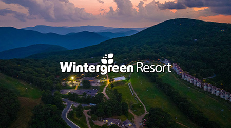

ABOUT WINTERGREEN RESORT
Treat yourself to magnificent mountain views, sumptuous luxury, and thrilling recreation at Wintergreen Resort. Spanning 11,000 acres on the eastern slopes of the Blue Ridge Mountains, our spacious condominiums and vacation homes are surrounded by winding trails, cascading streams and lush forests. The ultimate four-season vacation or conference spot, Wintergreen Resort is peaceful and refreshing, with an endless variety of activities.
Maps + More
Mountain + Village Map

Winter Trail Map
Membership Newsletter | Summer 2023
Media Relations
- #1 Best Resort – Virginia Living “Best of Virginia 2023”
- 2014 The Piedmont Virginian – Best of the Piedmont
- Best Reception Location
- Best Holiday Celebrations
- Best Spa
- Best Musical Event – Wintergreen Summer Music Festival
- Best Non-Profit – Wintergreen Performing Arts
- OnTheSnow.com Visitors Choice Award for one of North America’s Favorite Resorts
- 2012 Best Resort in Central Virginia, Virginia Living Magazine
- 2011 Charlottesville Welcome Awards for #1 Ski Resort and #3 Resort
- Albemarle Family Gold Award for Favorite Local Resort 2009 and 2010
- Best Snow Skiing Spot in the Washington Post’s Express Best of 2009
- Golf World Readers’ Choice Awards, State by State – Virginia
- 2024 Top Virginia Employers for Interns – The Virginia Talent + Opportunity Partnership
- #1 Best Resort – Virginia Living “Best of Virginia 2025”
- 2025 Bronze Medal Tennis Resort – Tennis Resorts Online
- 2012 Best Resort in Central Virginia, Virginia Living Magazine
- 2011 Charlottesville Welcome Awards for #1 Ski Resort and #3 Resort
- Gold Award for “Favorite Local Resort 2009, 2010 ” by Albemarle Family
- “Best snow skiing spot” in the Washington Post’s Express Best of 2009
- Golf World Readers’ Choice Awards, State by State – Virginia
- OnTheSnow.com Visitors Choice Award for one of North America’s Favorite Resorts
- 2012 Best Resort in Central Virginia, Virginia Living Magazine
- 2011 Charlottesville Welcome Awards for #1 Ski Resort and #3 Resort
- Gold Award for “Favorite Local Resort 2009, 2010 ” by Albemarle Family
- “Best snow skiing spot” in the Washington Post’s Express Best of 2009
- Golf World Readers’ Choice Awards, State by State – Virginia
- OnTheSnow.com Visitors Choice Award for one of North America’s Favorite Resorts
DRONE POLICY
Out of safety concerns for guests, members, employees, and resort property, as well as concerns for individual privacy, Wintergreen Resort prohibits the operation or use of remote aerial systems or drones by the general public – including recreational users and hobbyists – without the prior written authorization from the Resort. This prohibition includes drones used for filming or videotaping and any drone use by media or journalists operating above or within 100 ft of Resort boundaries.
This prohibition on drone operations or use extends to any drone launched or operated from Resort property and drones launched from private property outside the Resort boundaries.
Please contact Zach Marlowe at [email protected] if you have questions or need prior authorization to operate aerial drones. FAA rules and regulations may govern any authorized operation of aerial drones, local law enforcement, and policies separately established by this Resort, including certification, training, insurance coverage indemnification requirements, and waivers or releases of liability.
Any violation of this policy may involve suspension of your skiing or snowboarding privileges, or the revocation of your season pass, as well as confiscation of any drone equipment, and may subject violators to any damages, including, but not limited to, damages for violations of privacy and/or physical or personal injuries or property damage, as well as regulatory fines and legal fees.
Gift Certificates
Looking for a Gift?
No matter who you’re shopping for, Wintergreen Gift Certificates are always a great gift idea. Certificates may be redeemed for:
- Any of our fine shops
- Skiing and riding (in person at the ticket window)
- Spa treatments
- Accommodations
- A fabulous meal at any of our restaurants
- Golf or tennis lessons and more
If you need to buy and send a gift certificate, we will add a $12.95 delivery fee. Please allow 5-7 days for delivery.
If you’re short on time, you can arrange to pick up your gift certificate at the Front Desk when you check-in.
Directions
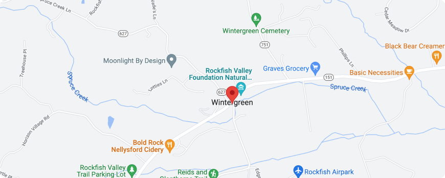
GPS Address: 39 Wintergreen Drive, Roseland, VA 22967
*During winter guests should avoid the parkway as it is often closed. You can find out road closures by clicking here and look for closures between milepost 0.0 at Rockfish Gap and milepost 27.2,
GETTING TO WINTERGREEN FROM:
VIRGINIA
WINCHESTER, FRONT ROYAL, WOODSTOCK, HARRISONBURG:
Take I-81 south to Staunton, then I-64 east to exit 99, turn right off exit onto route 250 west, take right on 151 south for 14.2 miles to route 664, take right and Wintergreen is 4.5 miles ahead.
WASHINGTON DC, ALEXANDRIA, FAIRFAX, ARLINGTON, MANASSAS, VIENNA:
Take I-66 west to route 29 south to Charlottesville, take I-64 west to exit 107, turn left off of exit onto route 250 west to route 151 south, turn left, continue 14.2 miles to route 664, turn right and Wintergreen is 4.5 miles ahead.
RICHMOND, VIRGINIA BEACH, NORFOLK, WILLIAMSBURG:
Take I-64 west to exit 107, turn left off of exit onto route 250 west to route 151 south, turn left, continue 14.2 miles to route 664, turn right and Wintergreen is 4.5 miles ahead.
PETERSBURG, HOPEWELL, COLONIAL HEIGHTS:
Take I-95 north to I-64 west to exit 107, turn left off of exit onto route 250 west to route 151 south, turn left, continue for 14.2 miles to route 664, turn right and Wintergreen is 4.5 miles ahead.
BRISTOL, WYTHEVILLE, ROANOKE, LEXINGTON:
Take I-81 north to I-64 east, continue to exit 99, turn right off of exit onto route 250 east to route 151 south, turn right, continue for 14.2 miles to route 664, turn right and Wintergreen is 4.5 miles ahead.
MARYLAND
BALTIMORE, LAUREL, COLLEGE PARK:
Take I-95 south to I-495 to I-66 west to route 29 south to Charlottesville, take I-64 west to exit 107, turn left off of exit onto route 250 west to route 151 south, turn left, continue for 14.2 miles to route 664, turn right and Wintergreen is 4.5 miles ahead.
POTOMAC, SILVER SPRING:
Take I-495 to I-66 west to route 29 south to Charlottesville, take I-64 west to exit 107, turn left off of exit onto route 250 west to route 151 south, turn left, continue for 14.2 miles to route 664, turn right and Wintergreen is 4.5 mile ahead.
NORTH CAROLINA
RALEIGH, DURHAM, DANVILLE, VA:
Take route 70 west to route 501 north to Lynchburg, VA, turn right onto route 29 north to Amherst, VA, then left onto route 151 north, continue for 21 miles to route 664, turn left and Wintergreen is 4.5 miles ahead.
ROCKY MOUNT, FAYETTVILLE:
Take I95 north to Richmond, VA then take I-64 west to Charlottesville to exit 107, turn left off of exit onto route 250 west to route 151 south, turn left, continue for 14.2 miles to route 664, turn right and Wintergreen is 4.5 miles ahead.
CHARLOTTE, GREENSBORO:
Take I-40 eat to route 29 north through Lynchburg, VA to Amherst, VA, then turn left onto route 151 north, continue for 21 miles to route 664 turn left and Wintergreen is 4.5 miles ahead.
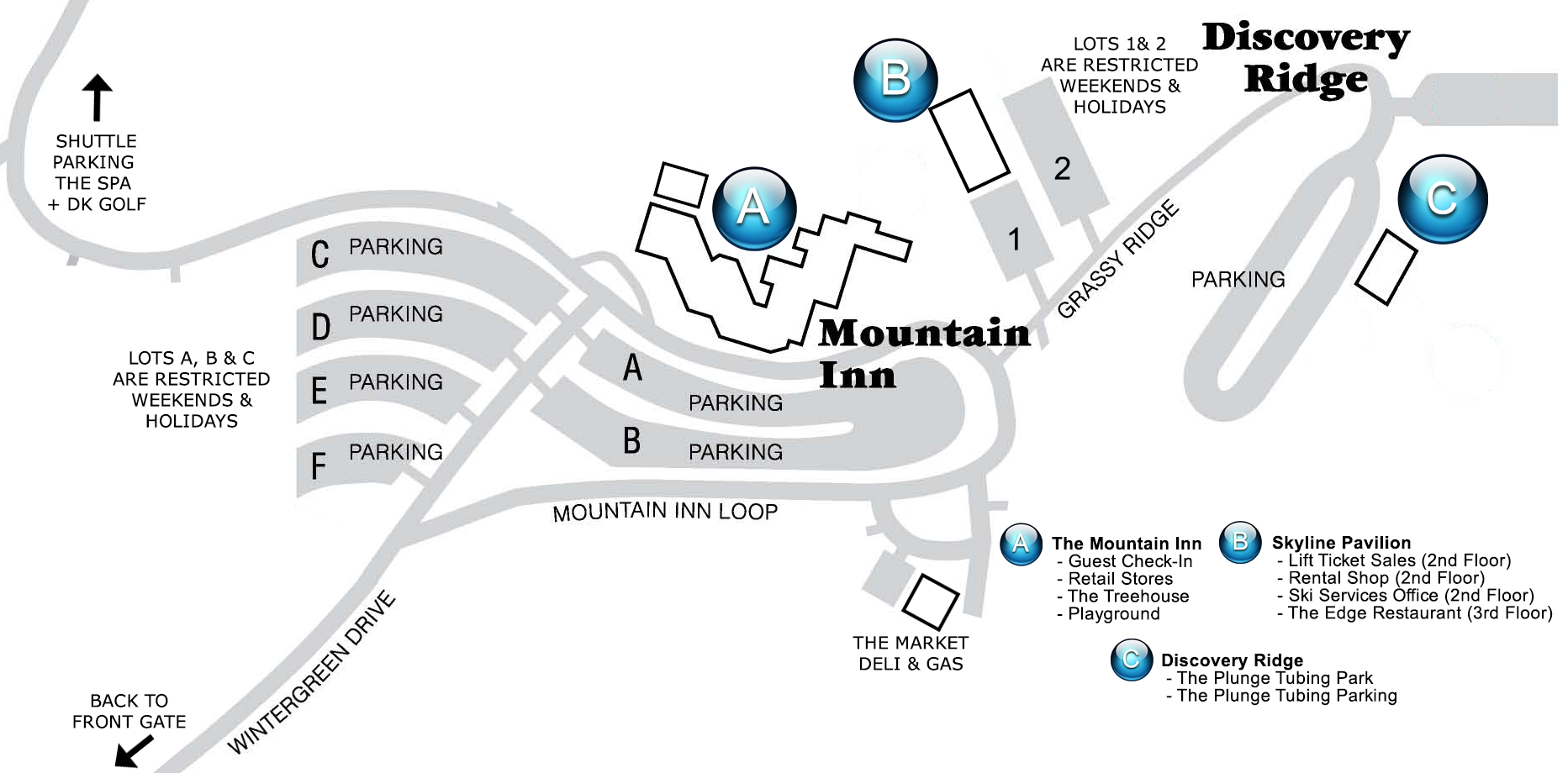
Parking at Wintergreen
Resort Event Vendor Information
Calling all talented art, craft, photography and other creatives to join us at our upcoming events. Showcase your unique creations amidst the sun-soaked scenery of our beautiful Resort and show off your creativity. Don’t miss these opportunities to be part of our Resort celebrations.
Apply now!


